Showing posts with label gps. Show all posts
Showing posts with label gps. Show all posts
Tuesday, November 13, 2018
Quantum compass and next generation navigation
https://gamesandtehories.blogspot.com/
Kimmo Huosionmaa
The vulnerabilities of GPS systems have been noticed, and that system has many weaknesses. The use of satellites makes it vulnerable to ASAT (Anti Satellite)-missiles, and another kind of weapons. That's why the military forces of the world are looking for the replacement for GPS. Even if the new systems, what bases the jumping frequencies are more immune to jamming than old systems, the replacement, what does not need satellites are now under the development.
Quantum compass might replace the GPS because it's immune to jamming systems. The major weaknesses of the GPS are the system uses satellites for giving the position of the point. And this is why GPS is quite easy to jam, and the other weaknesses are that the system cannot be used in underground or EMP-protected places.
Also, northern lights are disturbing that device, because they form ion layer in the top of the atmosphere. This means that the operators, who use GPS must find another way to locate themselves. The answer in submarines has been to use the Inertial navigation system, what connects the information of the speed of the thing, what uses that system, and the gyroscope meters the direction of the ship or aircraft. In modern gyroscopes, the layer would lay in the magnetic field, and it is rotating like in the electric motors. The lasers would observe the direction and positioning of that magnetic plate, what reacts extreme sharply in any changes in direction of the system.
By using this information can the computer map the position, if the beginning point of the journey is known in the vehicle. This navigation system can map the entire route of the navigated thing. But this system requires the begin location for mapping, or it is useless. This is the problem with this system. Also, the problem is to make it enough small that person can carry it in the pocket, and the need of speed information makes this thing hard to use in ground vehicles. Setting the beginning point of navigation is also difficult if the person jumps by using a parachute, where the beginning point is hard to locate.
The answer for the problem could be the very sharp magnetic compass, what bases technology, where the layer is floating in the magnetic field, and the multiple lasers are observing the position of that thing. The new kind of systems might be the combination, where is magnetic and gyro compass working together. Those systems might be very small and that would make them very light and effective.
The magnetic version of this compass works with a similar principle with normal magnetic compass, and the system calculates the place of the system by using the angle of the north pole for locating the system. The difference between the Inertial navigation system is that the plate must be in a stable position. There would be extremely thin magnet nail on it, and that makes possible to locate the magnetic north pole very sharply.
If those systems are based with nanotechnology, where the plates are extremely thin, and the width will be the only couple of micrometers and the size is smaller than coin or even the thumbtacks, the system would be extremely small. But of course, the operator needs more information and one is the knowledge about where the system is. So the operator must put the state or some coordinates, where he might be, that the computer can locate the person. This might be the next generation locating system.

Thursday, August 2, 2018
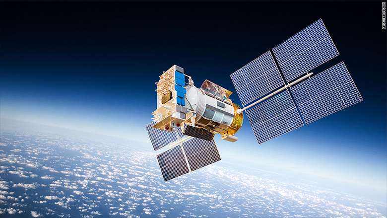
The GPS satellites are not so easy to target as people think (Installing "Trophy-system into satellites)
 |
| Picture I |
Kimmo Huosionmaa
GPS (Global Positioning Satellite) is a very good target for ASAT (Anti Satellite Weapons) because this satellite is giving the data for positioning for satellite-guided weapons like JDAM (Joint Direct Atack Munition) and GPS guided bombs and missiles. Those weapons allow that combat aircraft would close in the target in free angle, and that makes those weapons so effective.
The GPS is the easiest way to locate the position of the own troops, warships, and aircraft. GPS is also used in the safety systems of some special cargo, what are the risk to get stolen like money and the nuclear weapons. This system sends the location information of those things, and that will make the stealing that equipment very difficult. If the security personnel would push the alarm button, that would send the information of emergency to the security company. And that's why GPS is the very vital role in the private or governmental security.
But if somebody would destroy the GPS-satellites the strike capacity of NATO task force will decrease, because the tactical support aircraft would need the precise information of own troops position. And that's why GPS-satellites are so important in those operations. But the use of ASAT-systems would cause big danger for those satellites. If the GPS-satellites are equipped with similar ADS-system, called "Trophy", what is used in the M-1 "Abrahms" tanks would that increase the probability of survivability, if the satellite would be getting attacked.
"Trophy"-type ADS is actually a microwave system, what uses multiple IR (Infra Red) sensors to detect incoming missiles, and then the microwave transmitter turns to those missiles, and the warhead of those missiles would be detonated too early. In the satellites that system might seem like some Sci-Fi space battle vehicle's gun turret. The similar system can easily install to the GPS-satellites, and that would allow destroying those incoming ASAT missiles. This would make some of those weapons unable to operate correctly. And that system would also be used against other satellites.
http://www.thedrive.com/the-war-zone/14966/images-emerge-of-m1a2-abrams-tank-equipped-with-trophy-active-protection-system
Picture I
https://i2.cdn.turner.com/money/dam/assets/150731152254-satellite-780x439.jpg
Thursday, June 7, 2018
The innovative emergency pill, what would call help for the people.
 |
| Picture I |
Kimmo Huosionmaa
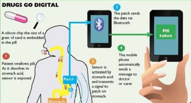
The NYPD has the first pill tracking system, what bases that the pills would be equipped with GPS-system. But there would be many more ways to create more sophisticated systems, what bases that technology. There could be the very bad thing for the pill like nitro pills, what are used for emergency, and that is that the person must call the emergency center or push some button for getting help.
Modern technology would give an opportunity for automatization of those processes. The answer would be the pill, what could be equipped with the transmitter, what can be connected to the smart telephone or some other system like GPS, and when the person would need help, could he just take the pill. The thing inside the pill or capsule would be the transmitter, what the person can eat, and then the stomach acid would activate the battery, what would give electricity for that device
When we are thinking about the use of this RFID-pill, in the point of view of the persons, who are working in dangerous situations and environment like forest guards, those persons can have many types of those pills. And if the person would be attacked by some animal, could this person take the yellow pill, and that transmitter would send the code to the smartphone and satellites, that the attacker was an animal, and if the pill could be red, would the transmitted code tell, that the attacker would be human. The green code would tell that the injury would be caused by the normal reasons. This idea of the intelligent transmitter, what can be eaten, I got the song in 2525, and maybe the person, who created the NYPD surveillance system got the ideas for that invention from the same sources, and there is only one threat with that system. That is, that if somebody would break the system by hacking, would that lead the burglaries to the addresses, where they can find those medicals.
This part, where the people takes the information from pill would seem like pure fantasy, but in the real life those pills could involve the transmitters, what would send the codes to the mobile telephones, and those codes could call the quadrocopter to the place, and that system can transmit the information straight to person brains by using high power radio waves. In the scenario, where the person takes "information pills", one code could mean, that the person would need full preparation of the things, what have happened from the history of humankind, from the stone age to nowadays.
And this might be the very fascinating idea for the training of tomorrow. There is only one danger, that system could be weaponized very easily. There would be devastating results if those systems would be used to control people. If those drones would make two crossing radio signals, what are connecting in the human head, the electric arc would be devastating, when it burns the brain tissue. If this would happen in the amygdala, the person would be lost the own will immediately.
This is one way of seeing this kind of devices misuse. In some book, the personnel was closed in the mental hospital, and when they ate their pills, would everything be alright. They had one implanted microchip in their body, and another would be eaten by those patients. If this fictional system would see two codes, it would be let those persons continue their working, but if it sees only one code, it would use that radio wave for exterminating that targeted person.
Sources
https://www.troab.com/fda-approved-smart-pill-with-digital-tracking-system/
Picture I
Saturday, April 21, 2018
Why are the crop circles made almost every time in Great Britain?
 |
| Picture I |
Below and above this text is links to document of crop circles, and the persons who are made some of them. If we have sharp GPS-system and very good draw for the map, we can make very difficult and complicated crop pictures in the field. This technology consists a picture what would position over the crop field and then the GPS coordinates would be put on the system, and then the persons can do that without no difficulties. They just copy the picture to the field.
And if the persons would have drones with GPS system and very high power blowers of hydrocarbon-like Acetone, they could make those signs very easily. But when we are thinking about the movie below, we must ask why somebody did crop circles in 1678? if the reason for making those crop circles is that people would not go out to see some secret military aircraft, the reason for that news from 1678 is simple, that news could be faked by MI-5 (The Security Service), what could be responsible for some of those hoaxes around the crop circles.
 |
| Picture II |
But there is another very important thing in this document. All crop circles are made in the areas, where is easy to go, and when we are thinking clearly, we must say that this kind of areas might be useful for delivering agents and special forces for missions against IRA. And some crop circles might cause the secret STEALTH aircraft operations, in the case, where some tornado comes from above, and that tornado can be forming because the STEALTH-helicopter would target the opposite rotating rotors to some place, and in this scenario the helicopters use the same kind of rotors as Kamov Ka-25 helicopters, what are used in Russian navy.
Those helicopters might look like saucers, and the rotors might be in the tube in the middle of the circular body. And when we are thinking about the case, that some farmer in Australia has seen UFO over the field. There were not mentioned about the year when this person made the observation. But this farmer might see the airship hanging over the cornfield. Also, the British military has been tested airships for military use, and sometimes I have thought, that those Zeppelin-style airships were misunderstood as UFO:s.
Sources:
https://www.youtube.com/watch?v=u5CLrAG1j5M
https://en.wikipedia.org/wiki/Kamov_Ka-25
Picture I
http://metro.co.uk/2016/08/16/was-this-crop-circle-created-by-a-bong-company-6071443/
Picture II
https://www.chroniclelive.co.uk/lifestyle/nostalgia/geordie-engineer-who-built-real-1417186
http://crisisofdemocracticstates.blogspot.fi/p/why-are-crop-circles-made-almost-every.html
Tuesday, April 17, 2018
The writing of strike to Syria again
travellingintimeandspace.wordpress.com/2018/04/17/the-writing-of-strike-to-syria-again/
travellingintimeandspace.wordpress.com/2018/04/17/the-writing-of-strike-to-syria-again/
travellingintimeandspace.wordpress.com/2018/04/17/the-writing-of-strike-to-syria-again/
travellingintimeandspace.wordpress.com/2018/04/17/the-writing-of-strike-to-syria-again/
travellingintimeandspace.wordpress.com/2018/04/17/the-writing-of-strike-to-syria-again/
travellingintimeandspace.wordpress.com/2018/04/17/the-writing-of-strike-to-syria-again/
travellingintimeandspace.wordpress.com/2018/04/17/the-writing-of-strike-to-syria-again/
travellingintimeandspace.wordpress.com/2018/04/17/the-writing-of-strike-to-syria-again/
travellingintimeandspace.wordpress.com/2018/04/17/the-writing-of-strike-to-syria-again/
travellingintimeandspace.wordpress.com/2018/04/17/the-writing-of-strike-to-syria-again/
travellingintimeandspace.wordpress.com/2018/04/17/the-writing-of-strike-to-syria-again/
travellingintimeandspace.wordpress.com/2018/04/17/the-writing-of-strike-to-syria-again/
travellingintimeandspace.wordpress.com/2018/04/17/the-writing-of-strike-to-syria-again/
travellingintimeandspace.wordpress.com/2018/04/17/the-writing-of-strike-to-syria-again/
travellingintimeandspace.wordpress.com/2018/04/17/the-writing-of-strike-to-syria-again/
travellingintimeandspace.wordpress.com/2018/04/17/the-writing-of-strike-to-syria-again/
travellingintimeandspace.wordpress.com/2018/04/17/the-writing-of-strike-to-syria-again/
Saturday, April 14, 2018
About the problems of weapons, what are used in Syria
travellingintimeandspace.wordpress.com/2018/04/14/about-the-problems-of-weapons-what-are-used-in-syria/
travellingintimeandspace.wordpress.com/2018/04/14/about-the-problems-of-weapons-what-are-used-in-syria/
travellingintimeandspace.wordpress.com/2018/04/14/about-the-problems-of-weapons-what-are-used-in-syria/
travellingintimeandspace.wordpress.com/2018/04/14/about-the-problems-of-weapons-what-are-used-in-syria/
travellingintimeandspace.wordpress.com/2018/04/14/about-the-problems-of-weapons-what-are-used-in-syria/
travellingintimeandspace.wordpress.com/2018/04/14/about-the-problems-of-weapons-what-are-used-in-syria/
travellingintimeandspace.wordpress.com/2018/04/14/about-the-problems-of-weapons-what-are-used-in-syria/
travellingintimeandspace.wordpress.com/2018/04/14/about-the-problems-of-weapons-what-are-used-in-syria/
travellingintimeandspace.wordpress.com/2018/04/14/about-the-problems-of-weapons-what-are-used-in-syria/
travellingintimeandspace.wordpress.com/2018/04/14/about-the-problems-of-weapons-what-are-used-in-syria/
travellingintimeandspace.wordpress.com/2018/04/14/about-the-problems-of-weapons-what-are-used-in-syria/
travellingintimeandspace.wordpress.com/2018/04/14/about-the-problems-of-weapons-what-are-used-in-syria/
travellingintimeandspace.wordpress.com/2018/04/14/about-the-problems-of-weapons-what-are-used-in-syria/
travellingintimeandspace.wordpress.com/2018/04/14/about-the-problems-of-weapons-what-are-used-in-syria/
travellingintimeandspace.wordpress.com/2018/04/14/about-the-problems-of-weapons-what-are-used-in-syria/
travellingintimeandspace.wordpress.com/2018/04/14/about-the-problems-of-weapons-what-are-used-in-syria/
travellingintimeandspace.wordpress.com/2018/04/14/about-the-problems-of-weapons-what-are-used-in-syria/
travellingintimeandspace.wordpress.com/2018/04/14/about-the-problems-of-weapons-what-are-used-in-syria/
travellingintimeandspace.wordpress.com/2018/04/14/about-the-problems-of-weapons-what-are-used-in-syria/
Tuesday, April 10, 2018
The jamming of GPS is the key element of modern military tactics
https://travellingintimeandspace.wordpress.com/2018/04/10/the-jamming-of-gps-is-the-key-element-of-modern-military-tactics/
https://travellingintimeandspace.wordpress.com/2018/04/10/the-jamming-of-gps-is-the-key-element-of-modern-military-tactics/
https://travellingintimeandspace.wordpress.com/2018/04/10/the-jamming-of-gps-is-the-key-element-of-modern-military-tactics/
https://travellingintimeandspace.wordpress.com/2018/04/10/the-jamming-of-gps-is-the-key-element-of-modern-military-tactics/
https://travellingintimeandspace.wordpress.com/2018/04/10/the-jamming-of-gps-is-the-key-element-of-modern-military-tactics/
https://travellingintimeandspace.wordpress.com/2018/04/10/the-jamming-of-gps-is-the-key-element-of-modern-military-tactics/
https://travellingintimeandspace.wordpress.com/2018/04/10/the-jamming-of-gps-is-the-key-element-of-modern-military-tactics/
https://travellingintimeandspace.wordpress.com/2018/04/10/the-jamming-of-gps-is-the-key-element-of-modern-military-tactics/
https://travellingintimeandspace.wordpress.com/2018/04/10/the-jamming-of-gps-is-the-key-element-of-modern-military-tactics/
https://travellingintimeandspace.wordpress.com/2018/04/10/the-jamming-of-gps-is-the-key-element-of-modern-military-tactics/
https://travellingintimeandspace.wordpress.com/2018/04/10/the-jamming-of-gps-is-the-key-element-of-modern-military-tactics/
https://travellingintimeandspace.wordpress.com/2018/04/10/the-jamming-of-gps-is-the-key-element-of-modern-military-tactics/
https://travellingintimeandspace.wordpress.com/2018/04/10/the-jamming-of-gps-is-the-key-element-of-modern-military-tactics/
Saturday, April 7, 2018
About the dominance of the space and world
luonnonihmeitakaikillamausteilla.wordpress.com/2018/04/07/about-the-dominance-of-the-space-and-world/
luonnonihmeitakaikillamausteilla.wordpress.com/2018/04/07/about-the-dominance-of-the-space-and-world/
luonnonihmeitakaikillamausteilla.wordpress.com/2018/04/07/about-the-dominance-of-the-space-and-world/
luonnonihmeitakaikillamausteilla.wordpress.com/2018/04/07/about-the-dominance-of-the-space-and-world/
luonnonihmeitakaikillamausteilla.wordpress.com/2018/04/07/about-the-dominance-of-the-space-and-world/
luonnonihmeitakaikillamausteilla.wordpress.com/2018/04/07/about-the-dominance-of-the-space-and-world/
luonnonihmeitakaikillamausteilla.wordpress.com/2018/04/07/about-the-dominance-of-the-space-and-world/
luonnonihmeitakaikillamausteilla.wordpress.com/2018/04/07/about-the-dominance-of-the-space-and-world/
luonnonihmeitakaikillamausteilla.wordpress.com/2018/04/07/about-the-dominance-of-the-space-and-world/
luonnonihmeitakaikillamausteilla.wordpress.com/2018/04/07/about-the-dominance-of-the-space-and-world/
luonnonihmeitakaikillamausteilla.wordpress.com/2018/04/07/about-the-dominance-of-the-space-and-world/
luonnonihmeitakaikillamausteilla.wordpress.com/2018/04/07/about-the-dominance-of-the-space-and-world/
luonnonihmeitakaikillamausteilla.wordpress.com/2018/04/07/about-the-dominance-of-the-space-and-world/
luonnonihmeitakaikillamausteilla.wordpress.com/2018/04/07/about-the-dominance-of-the-space-and-world/
luonnonihmeitakaikillamausteilla.wordpress.com/2018/04/07/about-the-dominance-of-the-space-and-world/
luonnonihmeitakaikillamausteilla.wordpress.com/2018/04/07/about-the-dominance-of-the-space-and-world/
luonnonihmeitakaikillamausteilla.wordpress.com/2018/04/07/about-the-dominance-of-the-space-and-world/
luonnonihmeitakaikillamausteilla.wordpress.com/2018/04/07/about-the-dominance-of-the-space-and-world/
luonnonihmeitakaikillamausteilla.wordpress.com/2018/04/07/about-the-dominance-of-the-space-and-world/
Wednesday, February 28, 2018
The use of mobile telephones as 3D scanners part II
 |
| (Picture 1) |
https://www.instagram.com/p/
Kimmo Huosionmaa
The technology what makes the mobile telephones 3D-scanners is actually the same, what is used to make 3D maps of Earth and other planets. In that technology satellites use radars and meters range between satellite and planet, what makes possible to make those maps, and modern computers and radars allow to make high-resolution 3D-maps, what can be zoom in very good accuracy.
By using VLF or ELF (Very or Extra Long Frequency) radars those satellites can make 3D maps from the ocean floor from the orbital trajectory. Same way ships can make 3D maps from the ocean floor, by using sonar systems. Also, Lidar or laser radars can be used in those mapping operations. Blue-green laser radars can scan very deep areas of the oceans, and that equipment can also meter the altitude and length of the waves.
But now I missed the thing, what I suppose to write. If the mobile telephones would be connected to drone-helicopters, and they could use enough sharp GPS-system, they could be used to scan very large areas. Of course, the system must know only the distance between the target and phone, and GPS is the very good tool to check the position of the telephone. But it could also work with triangle metering. The changes between the position of the drone and perfect circle can be the addition or subtract from the perfect circle.
That equipment works like satellites, but they are much smaller. And they can scan even entire buildings or ships by using their SONARS. So this might be new role fort smart telephones, what can now use in many things. And if that telephone would cover with waterproof cores and underwater drones it can use to scan entire fish, atolls or shipwrecks. Also, intelligence services can use those things to make 3D-models of submarines. Only thing what is necessary is that SONAR signal must pass the core.
Sources
https://www.instagram.com/p/
Picture 1
https://lmi3d.com/sites/default/files/phone_scan_04_0.jpg
http://crisisofdemocracticstates.blogspot.fi/p/the-use-mobile-telephones-as-3d.html
Tuesday, February 27, 2018
How can the mobile telephone be used as 3D-modelling?
 |
| (Picture 1) |
https://www.instagram.com/p/
Kimmo Huosionmaa
How can the mobile telephone be used as 3D-modelling? The answer to that question is simple. This thing uses the same device, what would focus lens of its camera. It also connects the data from the camera of that telephone. So this makes those mobile telephones very sophisticated tools for modeling. The problem of those scanners is that the mobile telephone must be absolutely stable, or the modeling would be failed.
But this can be solved by using selfie-stick, what is installed on the table or stable platform, and if the hands of the stable enough, the scanning can make by keeping the device in hand. But the fixing of this problem could be found from GPS. If this system would be sharp enough, the telephone could fix the errors, what shaking hands causes. In this solution, the GPS would map the place where the telephone is in the sharpness of only small part of the millimeter, and the computer would calculate the errors of the metering.
The system would take the original point, when scanning is beginning, and then it would fix the error what the shaking of hands might cause. This would be done by adding or subtracting the location in the real world of the phone, from the values of the pure ring. This would make the scanning more easier. This little program can revolutionize the CAM (Computer Aided Manufacturing) -technology. Now any firm can buy this kind of equipment and use it as making 3D-models for CAD programs and 3D printers.
In this system, the computer in the mobile telephone transmits the distance between the target and telephone by using sonar. Sonar is almost as effective scanning tool as a laser, but the sound travels in the air much slower than air.
The optics of the mobile telephone would focus using Sonar and the situation where the user notices it is when this person wants to take a picture what portraits horizon. In this case, the system of the camera cannot get an echo from the surface, and the optics of camera cannot focus the image.
I have read some articles that same radars what are used in traffic light as traffic calculation sensors could be mounted to RPV-helicopters. Those helicopters can be used to make 3D-models of entire building areas. They use oblique scanning, what is connected to GPS and computing platforms to make 3D models of buildings. The computers would make 3D pictures by those pictures, what this device sends to computers.
Sources:
Picture 1
http://crisisofdemocracticstates.blogspot.fi/p/how-can-mobile-telephone-be-used-as-3d.html
Saturday, February 24, 2018

Monday, January 29, 2018

Saturday, January 27, 2018

Sunday, December 17, 2017


Saturday, October 21, 2017
What about advanced biological weapons?
 |
| (Echis Pyramidum) |
Kimmo Huosionmaa
The biological weapon could be snake what poison is used in lethal injections. Those reptilians normally bite some people, and the strike with those animals poison is very dangerous. If an assassin will get snake poison he will be very dangerous. If an assassin wants to cover his murderous action he might pay his target a trip to India, and finds a snake called Efa (Echis Pyramidum). After that, he must milk that snake's poison and put it with an injection to his victim. I wrote that thing ones or twice, and I must say that I read in from one novel.
When we are talking about biological weapons, we always think about viruses and bacteria what cause lethal infections. But there are many other lifeforms what will use as bioweapons without leaving a trace. Those animals are the most feared beasts in our planet. The simplest way to cause a terrible situation with the small investment if some naval base is in tropic is just fall blood to that harbor and bring sharks in that place. Sharks get mad in that kind of action, and if some unauthorized person swims in that area, that person will be eliminated by sharks immediately.
Same kind of action might be done with piranhas. Those flesh-eating fishes are the most feared animals on the planet. The Same thing might be done with bugs like Wasps and another kind of hymenopteran bugs will cause extremely painful bites even without any stimulants. But in case of hymenopterans, the problem is that those tiny bugs aggressivity is very easy to increase. Just deliver acetone in the air is enough to make those bugs very aggressive.
So system what is needed is so simple that anybody can build it. Only thing what is needed is a hive where is injected acetone. That system can be carried in the operational area by airplane or helicopter, and it can be dropped above targets. Then acetone will release to the tank, where bugs are. But did you know that those animals can use to find explosives?
The key in that process is to grow those bugs o the bed where is explosives, what are used in ammunition. If those bugs will put to that bomb, they will look for people who carry ammunition, and if acetone boosts aggressive behavior of those bugs that will make the very bad situation for some fighters. But also rats and mice can be trained to find things like drugs. It’s enough that when those little mammals are grown with drugs. Those drugs make them narcomaniacs, and after that, they will automatically begin to search drugs and begin to eat those stuff from the hidden places, where they will bite holes to plastic bags and destroy all kind drugs what they can find. But those little troublemakers can be trained very fast to look for explosives.
Just offer captured mouse and rats food where is a very addictive drug, and after that those animals can be equipped with GPS systems,.what helps operators to follow those animals, and that stuff might have miniature cameras, where that military personnel might identify the target before they order airstrike to the targeted explosive warehouse. The food what is needed is a mixture of explosives, strong opiate and some normal food what that kind of animals normally eat. And after that, they will connect explosives to food. Conditioning those animals might take the only couple of hours, and those rats are excellent because people don’t like them.
But let’s go back with bugs. If those bugs are marked with microchips where is RFID radio, those bugs what are grown on explosives might look for mines. That system what puts microchip to bugs bag could be same, what is used to build micro-components. In the door of the hive is system what puts that chip to bugs, and they are followed by nano-copters what are equipped with RFID systems, what is allowed to follow those bugs. And if many of those bugs are coming together, they will show operators a place of hidden explosives. The Same system can be used by searching bodies. Blowflies can be implanted by the same system, and they are effective to look for hidden graves. Most fascinating thing about those systems is use birds as bombers.
The bird can be trained the same way as dogs, and if they will train to take explosives like “frag grenades" with their claws and drop them to their targets those birds might be dangerous even for armored vehicles. Big birds like condors might train to drop HEAT ( High Explosive Anti-tank ammunition) on the tank's surface, and they can destroy even heavy main battle tanks. The system might be radio and the small camera. And by that system operators give orders to the bird when it should release the touch. But this might be still fiction. This opportunity is a very fascinated thing to use birds as bio-robots.
Tuesday, August 8, 2017
GPS (Global Positioning System) tarvitsee myös tehokkaan "Backup-järjestelmän", jotta jos sen satelliitteihin kohdennetaan jonkinlainen isku, niin navigoinnin tarkkuus ei kuitenkaan laske.
 |
| GPS-satelliitti |
Kyberturvallisuus voi palauttaa vanhanaikaisen LORAN-laitteen takaisin arvoon arvaamattomaan. LORAN on siis vanhanaikainen merillä käytettävä kolmiomittaukseen perustuva navigaatio-laite, joka perustuu siihen, että laivassa oleva suuntomoradio ottaa suuntiman kahteen tai kolmeen maalla olevaan kiinteään radioasemaan, ja sitten noiden suuntimalaitteen antamien kulmien avulla laiva tai lentokone paikantaa itsensä valtamerillä, missä ei ole käytettävissä maamerkkejä.
Nykyisin LORAN-laite on korvattu lähes kokonaan satelliittien kautta toimivilla GPS (Global Positioning System)-laitteilla, mutta noiden laitteiden ongelma on siinä, että GPS-satelliitit voidaan hakkeroida, ja jos tuo hakkerointi tapahtuu oikealla hetkellä, niin esimerkiksi sukellusveneen tai sota-aluksen kyky paikantaa itsensä vaarantuu. Jos tuo hetki on se, kun alus laukaisee ohjuksensa, niin silloin tuo ase voi lentää jopa kilometrien verran sivuun kohteestaan. Kuitenkin LORAN-aseman heikkous on siinä, että sen paikka on helppo suuntia, ja sitä vastaan voidaan hyökätä tutkaan tai muuhun radioaaltoja säteilevään kohteeseen kuten WLAN-sekä GSM-tukiasemiin hakeutuvilla ohjuksilla, jotka tuhoavat sen antennit hyvin tehokkaasti.
Toisaalta noihin GPS-järjestelmän satelliitteihin voidaan kohdentaa ASAT-aseita, jotka hakeutuvat kohteeseen tuon satelliitin lähettämän radiosäteilyn avulla. Eli tuolloin kyseessä on siilosta tai mobiiliasemasta laukaistava suurikokoinen radiomaaleja kohti hakeutuva ohjus, joka voi olla kohtalokas myös LACROSSE:n kaltaiselle tutkasatelliitille. GPS- ja tutkasatelliitteja vastaan suunnattu ASAT-ase olisi ikään kuin jättimäinen HARM (High Speed Anti Radiation Missile)- ohjus, ja se sitten voisi olla Pegasus-raketin muunnos, joka voidaan laukaista esimerkiksi TU-26 “Backfire” tai B-52 pommittajan siiven alta. Tuon takia on ajateltu, että perinteisen LORAN-laitteen modernisoitu versio voisi toimia GPS:n rinnalla ikään kuin varmistusjärjestelmänä, jossa lentokone tai laiva kykenee paikantamaan itsensä lähettämättä itse elektronista ääntä.
Tuo kyky on hyvin tärkeä, jos esimerkiksi kyseessä on STEALTH-operaatiosta, niin silloin pienikin elektroninen signaali voi paljastaa STEALTH-pommikoneen sijainnin, ja sen takia koneen kyky käyttää maastokuvion vertailuun perustuvaa navigointia iskun aikana voi olla kohtalokasta. Tuo maastovertailuun perustuva navigointijärjestelmä on nimeltään DSMAC (Digital Scene-Matching Area Correlation), ja se toimii samalla tavoin kuin risteilyohjuksissa käytetty tämän navigointilaitteen versio, eli ensin maapallon kiertoradalla oleva satelliitti ottaa tuon lentokoneen aiotusta reitistä tutka- sekä muita valokuvia, jotka sitten siirretään STEALTH-pommikoneen tietokoneen muistiin.
Sitten lentokoneen autopilotin kontrolli-tietokone vertaa muistissaan olevia kuvia niihin kuviin, mitä sen tutkat sekä kamerat syöttävät koneen tietojärjestelmälle. Tutkan käyttö noiden “genimap”-kuvien luomiseen on sikäli kannattavaa, että silloin voidaan eliminoida sään vaikutus navigointilaitteisiin, ja tuolloin lentokoneen pohjassa oleva altimetritutka kuvaa samalla koneen alla olevaa maata, jotta lentokone pysyisi oikealla reitillä.
Tutkaan perustuva korkeusmittari auttaa koneen autopilottia pitämään se absoluuttisella korkeudella maan pinnasta. Tuo aktiivinen lentokorkeuden mittaaminen antaa lentokoneelle mahdollisuuden lentää jatkuvasti esimerkiksi 200 metrin päässä maan pinnasta vaikka kone lentäisi mäkisellä tai vuoristoisella alueella. Ja jos autopilotti on varustettu tekoälyllä, niin lentokone sitten kykenee välttämään törmäyksen maahan myös silloin kun lentäjä on kytkenyt automaattiohjauksen päälle, ehkä siksi että hän haluaa tehdä vielä jotain varmistuksia ennen pommien tai ohjusten laukaisua.
Tuollainen kone kuitenkin on helppo havaita radiosuuntauslaitteella, ja siihen voidaan kohdentaa IT-tykkien tulitusta. Nykyaikaiset nopeat IT-tykit voidaan varustaa lämpökameroilla, joiden avulla jopa STEALTH-koneiden pakokaasut saadaan näkyviksi, ja tietenkin tuollaisella tykillä voidaan ampua varsinkin keskikorkeudella lentäviä STEALTH-koneita alas. Samoin esimerkiksi mikroaalto- sekä laseraseet voivat tuhota noita koneita hyvin tehokkaasti, jos ne vain ensin havaitsevat nuo tutkassa näkymättömät koneet. Ja nykyään myös esimerkiksi SU-27 hävittäjissä on FLIR (Forward Looking Infra Red) eli eteenpäin katsova infrapunakamera, jolla se löytää hyvin helposti maan lähellä lentävät STEALTH-koneet. Tiedetään että Venäjällä on käytössään pitkälle kehitettyjä Laseriin ja muihin sähkömagneettisiin sätelyn lajeihin perustuvia aseita, joiden avulla se kykenee tuhoamaan havaitsemansa STEALTH-koneen.
Kuitenkin tuollainen tilanne, missä kohteena ovat terroristit, on mahdollista käyttää jopa robottilentokoneita, jotka voivat iskeä autonomisesti kohteeseen. ja juuri näitä autonomisia robotteja pidetään erittäin suurena uhkana maailmanrauhalle. Kyseessä on siis esimerkiksi SU-27 tai F-15 hävittäjäpommittajan robottiversio, ja kehittyneen tekoälyn avulla nuo lentokoneet kykenevät väistämään myös niitä vastaan ammuttuja ohjuksia, ja vaikka kone menetettäisiin tuollaisessa operaatiossa, niin silloin ei kuitenkaan lentäjä vahingoitu tai vaarannu. Jos käytössä on selektiivinen laitteisto, niin silloin voidaan kohteet määrittää siten, että tiettyjä kohteita kuten suuria sota-aluksia sekä ballistisia ohjuksia kuljettavia yksiköitä vastaan voi tuo hävittäjä sitten tehdä myös “kamikaze”-hyökkäyksiä.
Eli tiettyjen kohteiden arvo viholliselle on niin suuri, että tuollainen robottikone voidaan myös ohjata kohdetta päin tällaisessa iskussa, ja vaara on siinä että esimerkiksi jonkun matkustaja- tai kuljetuskoneen autopilotin ohjelmisto korvataan tällaisella ohjuksissa sekä rynnäkköroboteissa käytettävällä ohjelmistolla.Tuolloin voi käydä niin, että tuo matkustaja- tai kuljetuskone voi lentää jotain taloa päin, jos lentäjät eivät saa autopilottia kytkettyä pois päältä. Robottien avulla ilman miehistöä lentävät pommikoneet eivät ole mitään sen ihmeellisempiä laitteita kuin mitä risteilyohjukset ovat.
Noissa operaatioissa käytettävät järjestelmät ovat oikeastaan aivan samoja, kuin mitä käytettiin Toisessa Maailmansodassa eli tuolloin voidaan käyttää LORAN-järjestelmää missä kohteen päälle on suunnattu ristikkäin kaksi radiosädettä, ja robottikone lentää toista sädettä pitkin, ja kun toinen säde on kohdistettu, niin että se leikkaa tämän “johtosäteen”, niin siinä kohtaan voi hävittäjä sitten pudottaa pomminsa tai kytkeä kohteentunnistimensa päälle. Roboteissa tuo tunnistin toimii siten, että sen tietokoneen muistiin on syötetty kuva kohteista, mitä halutaan tuhota, ja sitten kun kohde näkyy, niin robotti tulittaa sitä esimerkiksi laser-ohjattavalla pommilla tai ohjuksella.
Tietenkin tuollaista LORAN-laitetta voidaan muuttaa niin, että se on myös tietoturvan kannalta järkevä käyttää, eli se voidaan koodata niin, että vain omat lentokoneet kykenevät hyödyntämään tätä järjestelmää. Nimittäin GPS-järjestelmän häirintä on yhtä helppoa kuin muidenkin digitaalisten tietojärjestelmien toiminnan estäminen. Esimerkiksi WLAN-verkkoja tai GPS-järjestelmää voidaan häiritä samoilla välineillä, millä häiritään normaaleja tutkia, ja sen takia juuri raskaat häirintäkoneet ovat suoranainen uhka mille tahansa GPS-laitteita tai WLAN-verkkoa hyödyntäville joukoille. Ja sen takia pitää myös GPS:lle kehittää joku korvaava järjestelmä, jos sen satelliitit joutuvat jostain syystä pois toiminnasta.
https://marxjatalous.blogspot.fi/
https://marxjatalous.blogspot.fi/
Thursday, July 13, 2017
GPS on todella herkkä häirinnälle, joten sen seuraajaa etsitään kuumeisesti
 |
| F-15 harjoituslennolla |
Koska GPS-laitteita häiritään yhä useammin, niin silloin täytyy kehittää uusia radioaalloista riippumattomia paikantamistapoja tuon tehokkaan mutta herkän laitteiston korvaajaksi, joista yksi lupaavimmista on käyttää satelliittiin kohdistettua koodattua LED-valoa lentokoneen erottamiseksi taustasta. Kyseinen laite olisi siis sellainen, että se näkyisi vaikkapa valokuvaustiedustelua suorittavan satelliitin kamerassa, ja sitten tuo laitteisto lähettää tuon kuvan alla lentäville hävittäjille, jotka voivat tuolla tavoin sitten paikantaa itsensä tuosta ilmakuvasta, jota tietenkin voidaan päivittää reaaliajassa. Ja tietenkin se toimisi myös korkealla lentävien ilmalaivojen sekä Global Hawk-lentokoneiden kanssa.
Taas on maailmalla tapahtunut kummia, ja Mustallamerellä on väitteiden mukaan ilmennyt GPS-laitteiden häirintää eli “spoofausta”. Tuolloin joko tuota laitteistoa häiritään ECM-laitteilla, mikä estää satelliittien lähettämien paikannussignaalien pääsyn laivojen tai lentokoneiden sekä muiden laitteiden antenneihin. Kyseinen väline estää satelliitteihin tukeutuvan paikannukseen käytettävän laitteiston käytön, mikä varmasti alentaa esimerkiksi GPS-pohjaisen tarkkuusmittauksiin käyttettävien laitteistojen käytettävyyttä.
Tällöin talojen pohjien mittauksiin käytettävien laitteiden sekä GPS-hakeutuvien ohjusten tai pommien käyttö muuttuu mahdottomaksi, koska tuo satelliittien signaali ei läpäise häirintää. Toinen tapa häiritä tuota GPS-laitetta on yksinkertaisesti lähettää samantapaisia signaaleja, mitä aito satelliitti käyttää kohteeseen aitoa laitteistoa suuremmalla teholla. Tuolloin häirintää suorittava satelliitti vain “huutaa” tuon aidon satelliitin yli, ja tuo jälkimmäinen vaihtoehto voi olla oikeasti paljon vaarallisempi, kuin pelkkä GPS-laitteiston toiminnan estäminen. Näet jos tuon satelliitin paikannuslaitteen koodit on murrettu, niin tilanne voi muuttua hyvin ikäväksi, koska tuolloin “rosvosatelliitti” voisi periaatteessa lähettää väärennettyjä paikannustietoja sen vaikutusalueella oleviin GPS-vastaanottimiin.
Tällaisella laitteistolla voidaan tehdä ainakin teoriassa sellainen temppu, että esimerkiksi ohjussukellusveneen kompassi käännetään niin sanoakseni ympäri. Tuolloin tilannetta voidaan verrata siihen, että jos sukellusvene ajaisi pohjoisen sijasta etelään, jolloin maailma olisi siihen nähden peilikuvana, ja tällöin voisi sitten seurauksena olla sellainen tilanne, että tuo sukellusvene sitten laukaisee ohjuksia vahingossa omia kaupunkeja vastaan. Tai jos sama sitten tapahtuu lennossa olevalle risteilyohjukselle, niin se suorittaa lennon aivan oikein, mutta kuitenkin sen suunta olisi vastakkainen, kuin mitä olisi aiottu. Kun puhutaan tuollaisista GPS-laitteisiin kohdistuvista uhista, niin tällainen väitetty massiivinen häirintä varmasti sitten voisi merkitä sitä, että joku voisi harjoitella tuollaista operaatiota. Tietenkin on olemassa myös vaihtoehtoisia paikannustapoja, jotka perustuvat kolmiomittaukseen.
Tuolloin laiva tai muu paikannusta tarvitseva on yleensä varustettu transponderilla, joka pitää sisällään laitteen tunnistuskoodin. Tuo väline voi toimia myös optisella alueella, eli kyseessä on tuolloin LED-valo, joka lähettää samanlaista koodia, kuin mitä esimerkiksi WLAN-verkko käyttää. Ja tuolloin kaksi kaukoputkea kohdennetaan tuohon lediin, joka ilmaisee silloin laitteen rekisterikoodin. Tämän jälkeen paikannuslaite sitten lähettää oman paikkatietonsa sekä kolmiomittauslaitteen kulmat tuolle paikannettavalle koneelle. Kyseisen järjestelmän avulla voidaan toteuttaa myös lentokoneiden välinen optinen WLAN, millä ne voivat jakaa tehokkaasti omien laitteidensa tietoja koneelta toiselle. Paikannuksessa optisten laitteiden ongelmana on se, että niillä pitää olla näköyhteys tuohon laitteistoon. Kuitenkin esimerkiksi yhdistettynä kaukokartoitus- tai valokuvaustiedustelua suorittavaan satelliittiin voisi tuollainen väline olla hyvin tehokas.
Tuolloin satelliitti lähettää lentokoneen digitaaliseen viestilaitteistoon kuvan alueesta, missä se lentää, ja sitten tuo laser-led saa aikaan sen, että tietokone osaa sitten liittää lentokoneen tuohon valokuvaan piteenä, jossa on sen oma tunnistustieto.Tuolloin voidaan päästä samaan tarkkuuteen kuin GPS:ää käytettäessä, kuten alussa kirjoitin.
Näet jos taistelutilanteessa tuo satelliittipaikannin ei toimi, niin silloin joudutaan turvautumaan toisenlaisiin järjestelmiin, joiden toiminta on rajoittuneempaa. Eli laserin avulla ohjattavien pommien käyttö aiheuittaa seen, että rynnäkkökoneen lentäjän mahdollisuus lähestyä kohdettaan on rajoittuneempi, ja samoin kohteen tunnistamisessa sekä hyökkäyksessä on tuolloin ongelmia. Näet tuolloin lentokone joutuu navigoimaan kohteeseen esimerkiksi inertia-navigaatiojärjestelmän avulla, mikä ei ole niin joustava kuin GPS. Ja vaikka tuo pommi olisi sellainen, missä laserilla näytetään kohde, ja sen jälkeen pommin inertia- eli hyrrään perustuva navigaatiojärjestelmä lentää aseen kohteeseensa, niin silloin on lentokoneen lentäjän tai pommia kohdistavan operaattorin oltava todella tarkkana, koska jos tuo laser on väärin kohdennettu, niin silloin pommin tarkkuus kärsii.
Tietenkin on olemassa myös TV-hakeutuvia ohjuksia sekä pommeja, mutta niiden käyttö on samanlaista kuin laserilla ohjattavien aseiden käyttö, eli yleensä operaattori suuntaa pommin tai ohjuksen päässä olevan laserin kohteeseen, ja sitten tuo ase lähtee liukumaan tuota maalia kohti. Tuolloin aseessa oleva tietokone mittaa laserosoittimen kulman, ja sitten se ohjaa sen ohjaussiivekkeitä niin, että ase kääntyy kohti maaliaan. Joissakin pienissä risteilyohjuksissa on tällainen laite, ja noita aseita voidaan käyttää myös maalilennokkeina. Esimerkiksi Saksalainen “Kormoran”- lennokki kyetään varustamaan taistelukärjellä, ja kun se sitten partioi vihollisen ilmatilassa, mihin se voidaan pudottaa vaikka rynnäkkökoneesta. Kun tuo laite havaitsee vihollisen, niin sen operaattori antaa sitten käskyn hyökätä, jolloin siihen liitetty rakettimoottori syttyy, ja kone ohjataan kohteeseensa.
https://marxjatalous.blogspot.fi/
https://marxjatalous.blogspot.fi/
Saturday, July 8, 2017
Voiko biohakkerointi tai GPS-paikannin vaarantaa ihmisen turvallisuuden? Eli kaikki maailman välineet ovat portti hyvään sekä pahaan.

Nykyään GSM-puhelimiin saa vaikka mitä lisävarusteita, joista yksi tietenkin on sykemittari, joka varmasti on erittäin mukava väline, mutta voiko tuollainen väline aiheuttaa ihmiselle oikeasti myös vaaratilanteita? Tuollainen ranteeseen kiinnitettävä sykemittari on kiinni puhelimessa langattoman yhteyden välityksellä, joten sen välittämä signaali voidaan tietenkin siepata, ja sitä kautta päästä käsiksi henkilön sydänkäyrään, joten tuolla tavoin sitten tietenkin esimerkiksi ihmisen yksityisyys voi vaarantua.
Kun puhutaan siitä, että normaalin ihmisen sydänkäyrään pääsee joku käsiksi, niin se ei varmaan mitään kovin vaarallista ole, mutta tuollaisia terveystietoja voidaan käyttää väärin, eli jos noista käyristä paljastuu sydänvika, niin silloin voi joku hyvin ovela rikollinen käyttää tuollaista tietoa hyväkseen, ja sitä kautta esimerkiksi antaa henkilölle sellaisia kemikaaleja, joilla sitten saadaan aiheutettua sydänkohtaus. Tuon kohtauksen aikaansaamiseen riittää se, että rintaan johdetaan voimakasta tasavirtaa, mikä sitten aiheuttaa sydämen pysähtymisen. Mutta tietenkin patologi yrittää selvittää sen, miksi henkilön sydän pysähtyy, ja silloin jos ei ole merkintää sydänviasta, on syytä epäillä henkirikosta. Samoin jos henkilön kalium- sekä klooripitoisuudet ovat epätavallisen korkeat on syytä epäillä kaliumkloraatti-pistosta, jolla on yritetty lavastaa sydänkohtausta.
Tuollaisten sykemittarien avulla voidaan ihmistä tarkkailla erittäin tarkasti, ja esimerkiksi hänen stressiään voidaan seurata sydämen sykkeen kautta. Eli kun ihminen stressaantuu, niin silloin syke tihenee, ja tuollaista laitetta voidaan käyttää vaikkapa silloin kun kartoitetaan ihmisen kykyä ajaa autolla. Kun koehenkilö istuu ratin taakse, niin tuollainen sykemittari voidaan asettaa hänen ranteeseensa, jolloin laitteisto voi havainnoida hänen kykyään toimia liikenteessä sekä samalla myös sitä, kuinka hän kiihtyy liikenteessä. Toki tuollaista biometristä tietoa keräävä laite voi olla käyttökelpoinen myös silloin, jos henkilön sopivuutta esimerkiksi lastenhoitajaksi arvioidaan.
Tuollainen väline havainnoi hyvin tehokkaasti ihmisen sykettä sekä verenpainetta, joka sitten tietenkin paljastaa sen, että kiihtyykö ihminen kovin helposti sellaisessa tilanteessa, missä hänen pitää olla rauhallinen. Biometristen tietojen avulla voidaan esimerkiksi urheilijan harjoitusohjelmaa muokata, niin että kunto-huippu saavutetaan nimenomaan kilpailuissa, mutta noiden välineiden avulla voidaan samalla myös etsiä ihmisiä, joilla on sellainen sydänvika, että heillä saattaa sydäninfarkti tulla voimakkaan rasituksen yhteydessä. Tällainen tietenkin kuulostaa loistavalta asialta, mutta kuitenkin on olemassa pelko siitä, että tuo tieto sitten päätyy jonkun asiattoman tahon käsiin ennen kuin tuolle kohde-henkilölle itselleen on kerrottu mitään.
Sitten edessä saattaa olla sellainen tilanne, missä joku saa päähänsä ryhtyä lavastamaan sydänkohtausta, koska tilaisuus tekee varkaan.Kuitenkin tällainen tieto voi pelastaa ihmisen hengen, jos hänet saadaan hoidon piiriin. Ja tietenkin häntä voidaan kehottaa välttämään esimerkiksi ultraurheilua kuten triathlonia. Eli nämä tunnistimet ovat kaksipiippuinen asia, josta kannattaa keskustella vähän tarkemmin.
Biometrisiä tunnistimia on nykyään lähes kaikkialla, ja yksi kaikkein eniten käytetyistä on puhelinten sormenjälkitunnistin. GSM-puhelin voidaan paikallistaa monella tavalla, joista yksi on tietenkin GPS, mutta myös verkon omaa kykyä ottaa ristisuuntima tuosta paikasta voidaan samalla tavoin hyödyntää. Tuo jälkimmäinen tapa paikantaa GSM-puhelin on oikeastaan vain merenkulussa käytettävän LORAN-paikannuksen muunnelma, ja toki myös LORAN-paikannuslaite voidaan koodata niin, että se lähettää samalla esimerkiksi laivan rekisteritietoja, jolloin maa-asema näkee aluksen tiedot.
Ja nykyään tuo laitteisto voidaan toteuttaa kaksisuuntaisesti, eli aluksen transponderi voidaan paikantaa LORAN-asemalta, samalla kuin aluksen radiosuuntimalaite ottaa suuntiman niin monesta asemasta, kuin silloin katsotaan tarpeelliseksi. GPS paikannus perustuu siihen, että kun tuollainen laite pyytää paikannusta, niin silloin se lähettää palvelupyynnön satelliittien ryhmälle, joka ensin kohdentaa omat antenninsa tuohon laitteeseen, ja sitten ne lähettävät ikään kuin tekstiviestin tuolle laitteelle. Ja miten sitten liikkuvan laitteen paikallistaminen tapahtuu? Tuolloin GPS-satelliitti yksinkertaisesti paikantaa kohdettaan hyvin monta kertaa peräkkäin, jolloin se voi seurata kohdettaan reaaliajassa.
Tuollainen paikannin sitten varmaan lähettää hyvin mielenkiintoista dataa, varsinkin jos sen avulla paikannetaan esimerkiksi insinööriajoa suorittavaa henkilöä, eli tuossa tapauksessa poliisi sitten katsoo, keitä tuossa autossa istuu, ja missä päin he sitten käyvät ajamassa. Tällainen tilanne voisi olla tarpeen silloin, kun etsitään sellaisia tapauksia, missä henkilön epäillään ostaneen tuon ajosuoritteen. Samoin voidaan kysyä sitä, että missä päin tuo auto on ajellut, ja jos noissa tiedoissa on sitten eroja GPS-tietojen kanssa, niin silloin voidaan kyllä miettiä sitä, että miksi joku olisi noita tietoja vääristellyt.
Mutta noiden samojen paikannustietojen avulla voidaan myös esimerkiksi täsmäpommi kohdistaa maaliinsa. Eli tuollainen laite voi tietenkin auttaa esimerkiksi ISIS-taistelijoiden löytämisessä, mutta sillä voi olla myös kauhistuttavia sivuvaikutuksia. Tällaista välinettä voidaan hyödyntää esimerkiksi salamurha-operaatioissa, missä lentokoneesta pudotetaan paperista tehty täsmäpommi, joka voi sitten kadota räjähdyksessä "kuin tuhka tuuleen".
Tuollaisten STEALTH-pommien rakenne on oikeastaan sellainen, että pahviputkeen on suljettu voimakasta räjähdettä kuten RDX:ää, ja noiden aseiden vaikutus perustuu lähinnä paineeseen. Tuolla tavoin saadaan aikaan hyvin tarkasti rajattu tuhoalue, mutta sivuvaikutuksena on se, että tällainen ase tuhoutuu täysin. Nämä pommit kehitettiin aikoinaan F-117 "Nighthawk"-konetta varten, jotta kone olisi vaikeammin havaittavissa pommilastista tulevan tutkakaiun kautta, mutta myöhemmin niitä on alettu hyödyntää myös normaaleissa tarkkuuspommituksissa, ja esimerkiksi Clancyn kirjassa "Isku Kolumbiaan" tuollaisen aseen avulla eliminoidaan joukko huumekauppiaita.
Eli tuo pommi suunnataan siinä siten, että nuo ilmaiskut sitten saadaan naamioitua autopommi-iskuiksi, jolloin STEALTH- pommin selluloosasta tehty kuori häviäisi oikeassakin tilanteessa tuollaisen voimakkaan RDX-panoksen räjähdyksessä lähes täysin. Sellaisen räjähdyksessä katoavan pommin avulla voidaan saada todella ikävää jälkeä aikaan, jos joku haluaa ryhtyä ilkeäksi. Ja muistakaa että lentäjille ei tuolloin tarvitse kertoa sitä, että he suorittavat tuollaista operaatiota. Heille voidaan vaikka sanoa kyseessä olevan harjoitus, jossa testataan laser-tai GPS-hakeutuvien pommien toimintaa, ja jos käytetään ensin mainittua, niin silloin tietenkin vain maassa olevien ohjaajien pitää tietää tuo kohde, ja lentokoneen navigointilaitteessa voi olla sellainen ruutu, missä ei näy karttoja ollenkaan, vaan pelkkä viiva, jota lentäjän pitää seurata. Tuolloin hän ei ehkä edes tiedä, mihin oikeasti tuollaisen pommin käy pudottamassa.
https://pimeakronikka.blogspot.fi/
Subscribe to:
Posts (Atom)
Could fast-spinning aerial vehicles be behind some UAP cases?
“The Phantom Twist drone’s unique rotation renders it almost invisible when in flight (Image Credit: Northwestern University).” (The Brief) ...

-
 On olemassa valtioita, joissa korruptiota ei ole siksi, että sitä koskevaa lainsäädäntöä ei ole ole olemassakaan. Tai tarkemmin sanoen ...
 -
 Vesistö Naruskajärveltä (Lähde: lähde: http://www.naruskajarvi.fi/www/jarvi/vesisto/) Oletteko koskaan kuullut sellaisesta ainees...
 -
 Kuten huomaatte, niin tämä Paciuksen patsas Helsingissä muistuttaa hiukan shakkipelin lähettinappulaa. Kuninkaallisessa vallankäytössä ...